.gif)
Download Mobile App 


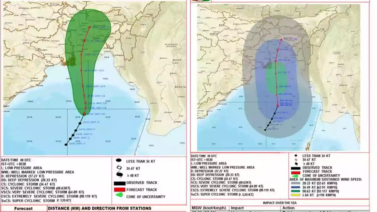
The India Meteorological Department (IMD) has announced that a "Deep Depression" over the East-central Bay of Bengal is likely to intensify into a cyclonic storm by this evening. According to the IMD, the storm is expected to cross between the Bangladesh and West Bengal coasts around Sunday midnight as a Severe Cyclonic Storm (SCS). The storm will bring wind speeds of 110-120 kmph, gusting to 135 kmph. In a statement, the IMD noted, "Depression over East central BoB intensified to Deep Depression over the same region about 380km S SE of Sagar Islands (WB) 490km S of Khepupara (Bangladesh). To intensify into a cyclonic storm by 25 evening and cross between Bangladesh and WB coasts around 26 midnight as SCS."
The IMD has issued warnings of heavy rainfall and storm surge for affected areas. A storm surge of about 1 meter above astronomical tide is expected to inundate low-lying areas of coastal West Bengal, while a surge of 3-4 meters above astronomical tide is anticipated for coastal Bangladesh around the time of landfall. Additionally, rainfall alerts have been issued for West Bengal and isolated heavy rainfall is predicted over North Coastal Odisha on May 25 and 26. The eastern districts of Sub-Himalayan West Bengal are expected to experience light to moderate rainfall on May 27 and 28. IMD scientist Dr. Somenath Dutta stated, "There was a low-pressure area over the southwest Bay of Bengal near the Chennai coast yesterday. That low-pressure area started moving in the northeast direction and it intensified a bit. On May 24, it will intensify into a depression. It will intensify into a cyclonic storm on May 25... The landfall will be at midnight on May 26."
.jpg)


.webp)
.webp)
.webp)
.webp)
.webp)

.webp)

 West Bengal
 Bihar
Bihar Uttar Pradesh
 Jharkhand